
Seine in flood
Seine in flood
It's at the Pont d'Austerlitz where they measure the water level of the Seine to determine whether or not it's flooding!!
Here are the most severe floods recorded since 1900
The 1910 Flood
On January 28, 1910, the water level at Austerlitz reached 8.62 meters, and the flow rate peaked at 2,500 cubic meters per second during the flood.
12 of Paris's 20 arrondissements were flooded
1 death
Here is the interior of the Orsay Train Station, which is now the Musée d'Orsay.
Photo credit: Petit, Pierre (Pierre Lanith Petit, known as) (studio of), photographer, CC0, via Wikimedia Commons
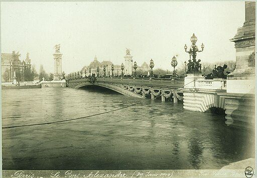
Paris, Alexandre III Bridge, January 29, 1910
Photo credit: Petit, Pierre (Pierre Lanith Petit, known as) (studio of), photographer, CC0, via Wikimedia Commons
View of City Hall from Île Saint-Louis
Photo credit: Forensic ID, photographer, CC0, via Wikimedia Commons
The 1924 Flood
January 6, 7.32 meters in Austerlitz
The Zouave on the Alma Bridge was up to his elbow in water on January 3, 1924, at 10:00 a.m.
,_3_janvier_1924_%C3%A0_10_h_-_photographie_de_presse_-_Agence_Rol_-_btv1b53123529w.jpg)
Photo credit National Library of France, CC0, via Wikimedia Commons
January 1955 Flood
January 23, 7.12 m in Austerlitz
January 1982 Flood
January 14: Water level of 6.18 m at Austerlitz
2016 Flood
On June 3, 4, and 5, 2016, thethe water level exceeded 6.10 meters in Austerlitz
4 dead and 24 injured
Zouave at the Alma Bridge

Photo credit Thesupermat, CC BY-SA 4.0, via Wikimedia Commons
The Léopold-Sédar-Senghor Footbridge Is Flooded!!

Photo credit: Djielle, CC BY-SA 4.0, via Wikimedia Commons
Orsay Museum

Photo credit:Thomon, CC BY-SA 4.0, via Wikimedia Commons
Notre Dame de Paris on June 5, 2016

Photo credit:Thesupermat, CC BY-SA 4.0, via Wikimedia Commons
Bridge of Arts

Photo credit Djielle, CC BY-SA 4.0, via Wikimedia Commons
Vert-Galant Square

Photo credit Djielle, CC BY-SA 4.0, via Wikimedia Commons